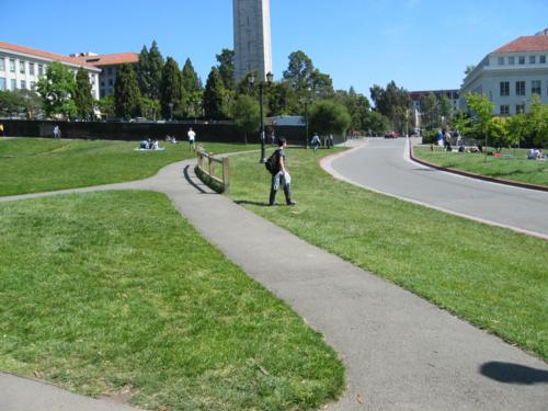
Walking on the UC Berkeley Campus, I saw this:
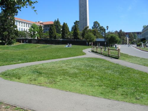
Hrm. That seems like an odd place to put a barrier. It’s not like there’s a cliff to fall over.
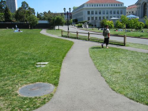
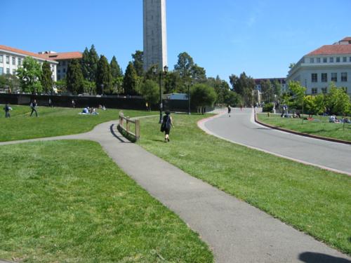
Another angle makes things a little more apparent:
Still don’t quite get it? How about this bird’s eye view, taken 3 years ago, from Kevin Fox’s “Berkeley Paths” photos (gallery no longer on line):
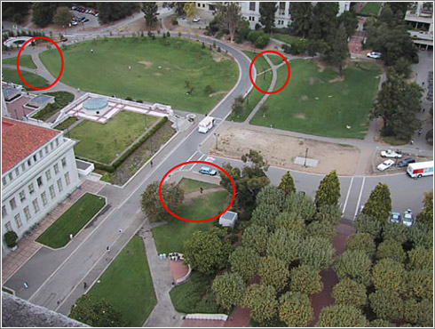
Look in the upper-middle-to-right-hand corner. See how there’s an asphalt path, heading from up-and-right to down-and-left, which is then continued by a dirt path, linking to the bend in the road??
Well, as this new photo demonstrates…
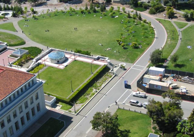
…that path is now gone. So, that barrier was designed to protect the grass.
In a presentation I gave a long time ago on emergent information architecture, I used the first birdseye photo to demonstrate how people will take a planned design and modify it to fit their needs. In the face of this, designers have two choices — allow the modification, or throw up obstacles (God forbid you digress from the original Vision!).
So, the landscape folk at Berkeley, in their foolishness, have chosen the latter. Not that it matters. People, being what they are, simply walk around it…
For shame!
There’s another interesting development. Look at the center of the first birdseye photo, and the bottom-right of the second. In the first, there’s a wide dirt path cutting across the corner. In the second, there’s a darker green patch, showing where it’s been re-sod.
For some reason, Berkeley would rather spend it’s money reinforcing it’s poor landscape architecture with barriers and re-sodding, then recognizing that the paths suggest a valuable will of the people.
Though, this is not always the case. In another part of the campus, diagonal concrete paths were laid where it was clear that people walked, and are still in use:
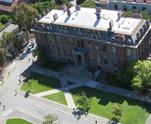
Pretty soon, Berkeley is going to have to face a new situation:
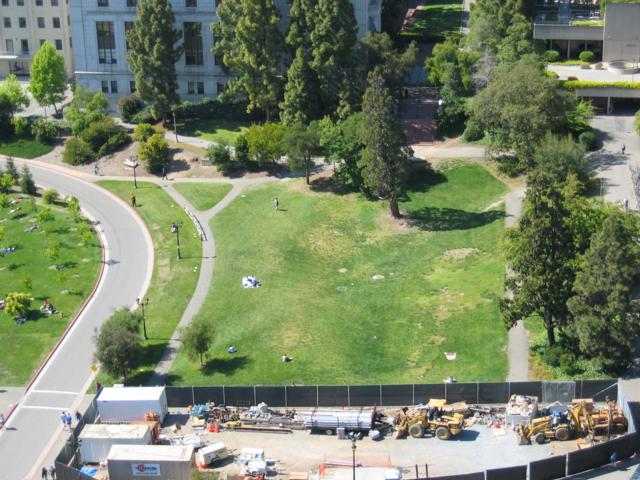
As you can see, a path is getting worn in across this field, crossing from the top-right to the bottom left (it continues paths already set in asphalt). Will Berkeley choose foolish fascism or opportunistic organicism? Time will tell…
According to Perl creater Larry Wall at UC Irving they took a much more elightened approach:
“I am told that when they built the University of California at Irvine, they did not put in any sidewalks the first year. Next year they came back and looked at where all the cow trails were in the grass and put the sidewalks there.”
[ http://www.softpanorama.org/People/Wall/larry_wall_articles_and_interviews.shtml ]
apocryphal? maybe, pretty good story though.
html link to that article for convenience.
William said:
“apocryphal? maybe, pretty good story though.”
And I wonder why everyone doesn’t do it that way. I came up with the same idea when I was in junior high school.
I am not a traffic engineer.
But judging by its placement and the curve in the road it looks like the fence was put there as a precautionary measure to stop, or atleast slow down, errant cars.
(We’ll leave whether or not a wooden fence is up to the job, for another discussion.)
It’s not hard to imagine that atleast one car has missed the curve, in the past, and swerved on to the grass.
Didn’t you present this at IA 2000? I seem to remember it.
As a traffic engineer, I can definitely say that fence was not placed for traffic, but rather for the pedestrians as Peter described. I am not certain about putting diagonal paths (as shown in second to last photo) are placed because that’s where people actually walk. Many campuses have “quads”, where paths cross each other at many angles as part of the landscaping.Many don’t serve a real purpose. They are there to make everything symmetrical.
Also, could the new warn path in the last photo be the result of a path lost by the construction shown? Maybe it’s temporary?
I think your examples here are good–the barrier seems like a lot of effort to protect such a small piece of turf.
On the other hand, opportunistic organicism isn’t always the right choice. If you’ve ever hiked up switchbacks, you’ll often notice a vertical path running through them made by clods who prefer to bushwhack straight down the mountain than follow the trail. The environmental damage caused by these secondary trails can be significant (killing flora, changing drainage patterns, etc.). Which is to say, sometimes the constraints imposed by the designer are meaningful.
William, I heard a version of that story from my grandfather (!), but about a college in either Utah or Arizona. Whether it’s actually true about any given college, it seems like a smart thing to do…assuming that your campus doesn’t have any switchbacks. 🙂
Similarly, I take the bus in the mornings to a strip mall where I meet my vanpool. There’s a strip of hedge between the sidewalk/bus stop and the parking lot, with no path directly from the bus stop to the parking lot, but the hedge hasn’t grown together yet, so it’s just a quick step down from the sidewalk.
Yesterday morning, I noticed that the main retail establishment had placed a row of carts all the way across that end of the parking lot, forcing the pedestrian/bus rider to walk out to the corner of the lot. (Which was especially annoying when I wasn’t quite awake….)
Since it’s the end of the lot *furthest* from the store, I can’t imagine any other purpose but to keep people from cutting through the hedge, such as it is.
I’m so glad I took those photos three years ago. It’s fascinating watching the evolution of the paths.
The interesting thing is that Berkeley clearly doesn’t have a standard plan of action regarding the reenforcement or inhibition of use-paths. At times they’ve paved them and other times they’ve blocked them, with ever-increasingly obtrusive obstacles. A lot of the time there’s no rhyme or reason to it.
Two notes about the newly forming diagonal path: First, that it’s new since the blocking of the old one with the fence, because bicycles want to come down there from speed and not steer around the fence or worse, miss the fence’s presence at night and hit it. Second, that they’ll almost certainly fence off the beginning of that path, likely fencing off the whole ridge. What the birds-eye doesn’t show is that it’s a steep hill at the right-edge of the path, and that bikes only go one way, down, through what was designed to be a playing field. They won’t pave it because it would break the playing field, and sanction a path too steep to walk up or down.
When I’m back in the Bay Area, I plan to revisit all of the use paths I photographed before, and see how they’ve changed.
If you vote for me I’ll not only have my varuois minions cut acros all switchbacks, but also have them paived. I’ll then replant the ugli old trails with olgrowth redwoods to help our ecomy.
A liturgy professor at Pacific School of Religion once took me on a route from PSR to UCB without walking up or downhill. Hire him.
Yoiks, I’ve been promoting the organic method of sidewalk placement for 20+ years. Here in the midwest we seldom (never?) have much to worry abouts concerning hills, so that’s usually a non-issue. And I would certainly forgive any safety related sidewalk or barrier placements.
However we do have well meaning civil engineer types that place sidewalks in all the -wrong- places, as is evidenced by the dying grass short-cuts in our towns, cities, malls, and universities, nearly always because they build them -before- the use patterns are realized. This is inevitably a (needless) money wasting exercise, at the time of building and over time as higher grounds maintenance costs rack up. It also is a major usability nuisance.
IMHO, these type of self-created ‘problems’ are usually easily fixed, though seldom recognized. These ‘problems’ are everywhere and we should all make an effort to fix them.
~dave
How ridiculous! Anyway, it goes to show that universities shouldn’t put in paths at all, cover the whole area with grass, and then wait and see what paths evolve naturally.
Then one can replace the human made paths with real paths. Who needs a computer model when you’ve got the real thing?
An other idea :
Maybe that fence was not placed for pedestrian traffic but for bikes (or something close like skateboard?) who liked to use the previous path.
The fence was just needed to force them to change their curve?
I have a feeling that the crossing paths in front of South Hall (I’m rusty on the building names at Cal) may be more about baroque aesthetics than actual use, but it could be either. Baroque diagonal axes tend to be more useful than right angle paths.
I’m sure Christopher Alexander talks about pathways, in either A Pattern Language or the book about the university his team designed.
So cute, the story of 30 or 40 students a day slowly making cow trails, and so on. Here in Tokyo, I walk to shcool from a train station, cutting across a little plaza and then around the flanks of a mall. Fascism is when: well, I reckon 1000 to 2000 people take the very same route I do before 9am, when the mall opens. Each one of us has to negotiate carefully placed barriers, at every major turn in the short cut, then walk over a sweet little hanging chain fence. And I am one of the few hundred who do it against the general flow of pedestrians. The clinchers: all the barriers and fences are removed at 9am, and we’re talking concrete here, the most durable kind of landscaping.
Richard: yes, Alexander talks about it in The Oregon Experiment. That (University of Oregon) is where they first let the students make their own paths, then the university came back and paved.
It seems to me that if as it was suested, bicyclists were coming down the hill at high speed and then following the path accross the grass onto the street the fence wa probably designed to stop them doing that, not pedestrian traffic. The university wants to keep people out of the street, especially speeding bicyclists, for safety reasons.
I think I’m even more obsessed with paths like this than most. The paths through the dirt where people naturally walk are called ‘Desire Lines’.
I’ve recently written a couple of papers about them and other Desire Lines you can look for, which you can read here… Carl’s Publications
Thanks for posting this Peter – I was planning on looking up this whole meme, and you’ve saved me some of the trouble!
At the end of the road where my parents live, and where I grew up, there’s a petrol/gas station, right on the corner. There are sidewalks around the edge, by the road, but many people have been cutting across the station forecourt for years – I always did on my way to school 25 years ago.
Over time the station has been changed and remodelled, with little attempt to either help or hinder those that walk across it. Except… to get into the forecourt, some people took an extra shortcut, walking across a flowerbed rather than entering where the sidewalk breaks to allow cars in. One day this little shortcut, worn into the earth, was semi-formalised with, IIRC, bricks being laid down across the flowerbed as a path.
Also, earlier this year I took this photo of some green space in Belgrade where a series of paths have been worn into the grass, criss-crossing the official paths: http://www.gyford.com/phil/photos/2004/04/serbia/?img=21_AdaptivePaths.jpg
Larry Wall is wrong about UC Irvine. I’m currently enrolled there, but–well, walking all the way to Aldritch park from my room would entail getting up. So let’s go to the tape.
Here’s a TerraServer photo from 1994:
http://terraserver.microsoft.com/image.aspx?t=1&s=10&x=2109&y=18615&z=11&w=1
While a lot of the outside of campus has changed, Aldritch park hasn’t.
The (interpolated to better than) 1 m resolution is just about right to see paths on campus. The bright white lines are concrete paths; the dim white lines are worn footpaths. (“Paths of desire”, as a friend used to call them.)
Note a LOT of places where a concrete path gently curves around the hill, hits another–and stops. Dead.
Note how often a worn footpath continues it.
–
It’s also clear in this photo
http://spds.ece.uci.edu/~gene/photogallery/uci2.jpg
(see the dirt path on the right side?)
and in this photo:
http://www.cusa.uci.edu/images/Aldrich-wd1.jpg
(center bottom as well as top right)
What an interesting discussion!
During my senior year at Michigan State, I took a transportation economics class & did my final project on the generation of dirt paths across campus lawns.
A smart math major friend and I developed a pretty good model to predict, a priori, where paths would form. The project is here, if you’re interested.
You’re pictures are of my home turf. So here’s the walker’s perspective:
(1) The diagonal paths on your 2nd to last photo (South Hall) were NOT placed where people actually walk. I worked in that building both before and after the paths were put in. I am always frustrated that I can’t just walk straight to the nearest door. The path takes me diagonally to the FAR door, or I have to zig-zag.
(2) In your first series about the barrier: an added problem in that section is that the walkway curves up the hill away from the street. People taking the main route from Euclid street and several campus parking lots (entering from the right side of your first picture, via the paths entering at the top of your 1st aerial photo) have to choose: go the extra distance on the walkway, or walk in the road. So lots of people walk in the road, which puts them in the narrow street, in conflict with traffic.
Re another post, no, barrier is not to protect walkers from errant cars nor does it do much for bikes. I could explain traffic patterns, but to keep this short, believe me, I walk that intersection nearly every day and it only protects the lawn.
Hi Peter,
I walked the path on your first scenario most days for the last two years, because it’s the fastest route between SIMS (the building in your second series of photos) and the JSchool (North Gate Hall). If you look at the path before the curve, on the left, there is a big sidewalk, and then it ends in grass, curving to the left. The street curves to the left, with no room for pedestrians going in that direction, with a steep downhill blind curve for cars coming uphill in the opposite direction. The grassy hillside deters pedestrians. So at about that point, a dangerous point for drivers coming quickly around the curve, pedestrians cross the street, to the dirt path you saw in the grass on the right side.
And going south, you end up walking the reverse route, crossing at the most dangerous point where cars would come around the curve, not see you and hit you from the back, as you are walking in their lane.
However, since there are far fewer cars in the middle of campus than walkers or bikers, it seems stupid that they put the fence up to keep us off the street, and stupid that they didn’t extend the sidewalk on the left side (west) of the street. It’s where everyone wants to walk, until the hill and curb get too dicy and you just walk into the road, crossing over to the fence/old dirt path.
I think they put the fence up to reduce liability because of the obtuse path situation and the fact that so many people walk it all the time, and don’t want to cross the street much earlier to go to an offical path, and then get around the fence the right way. Particularly not with such a large campus and only 10 minutes between classes. We are way too rushed to worry about staying on the officially designated paths.
I have a feeling that the crossing paths in front of South Hall (I’m rusty on the building names at Cal) may be more about baroque aesthetics than actual use, but it could be either. Baroque diagonal axes tend to be more useful than right angle paths.
I’m sure Christopher Alexander talks about pathways, in either A Pattern Language or the book about the university his team designed.
David Flores
Peter, No shit. I am writing a book on cowpaths. I am a professor at Bucks County Community College with an MUP from NYU. Do you have any book lists or more photos? Please help. This site is a God send.
Tony D
Wow, great post! I only wish I had found it a couple of years sooner. 🙂 I have been wondering about the true origin of the footpaths/cowpaths for quite some time now.