« more brief new york stories | Main | Workshop - User Interfaces for Physical Spaces »
November 05, 2005
Yahoo creates the first decent road trip mapping program
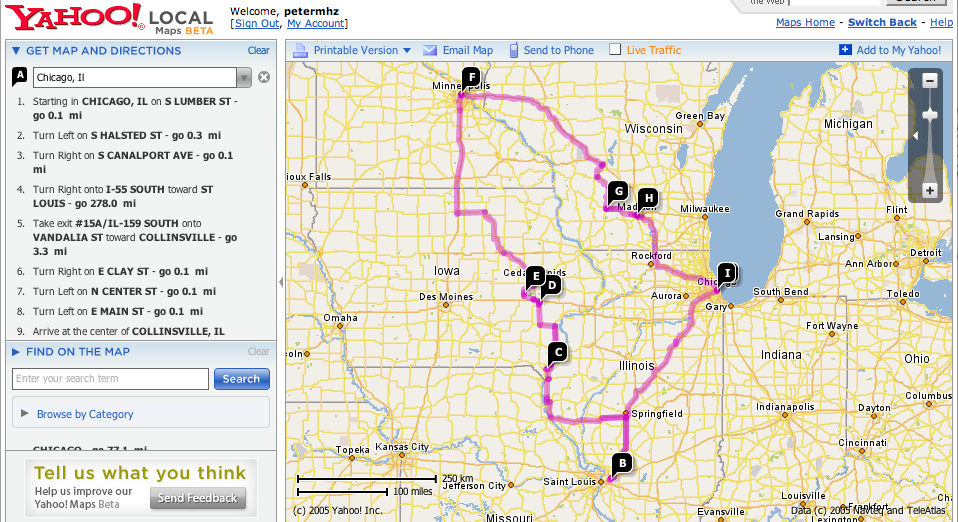
Yahoo has released a beta of their new super swanky mapping program, clearly a salvo fired in the direction of Google Maps. It uses Flash (instead of Ajax), and it by-and-large feels like Google Maps, except for one key exception: the ease of creating road trip itineraries.
I love road trips. I love the web. I've long hated that I can't create a decent road trip itinerary on the Web. None of the standard mapping sites (Mapquest, Google, old Yahoo) offered the ability to connect more than two points. The travel sites that offered road trip maps (Rand McNally, AAA), typically had shitty shitty interfaces, and bizarre restrictions (Rand McNally allowed for only 10 destinations on your itinerary).
Playing around with the beta Yahoo Maps, I saw that you can just keep adding destinations, and they keep stringing them together. In no time, I was able to recreate the road trip I took this past spring.
Some drawbacks:
It's not clear that you can save an itinerary. I think you might be able to through "email this," but that's a bit of a hack.
The rendering of the map information is still ugly. Anti-aliasing, people! Love it!
Posted by peterme at November 5, 2005 02:09 AM
Trackback Pings
TrackBack URL for this entry:
http://www.peterme.com/mt/mt-tb.cgi/359
Comments
Peter,
The URL auto updates and should let you just copy and paste the itinerary. i.e., it's always a permalink up there.
Posted by: Kevin Cheng at November 5, 2005 11:39 AM
Wow! An answer from the designer himself. Now, THAT's service :-)
Posted by: lantzilla at November 6, 2005 12:04 AM
The new Yahoo mapping is a significant improvement over their previous. And it is, like Google, useful and free.
Neither of them, however, come close to the complete trip designing package of Microsoft Streets and Trips which, though not free, I have found to be better than the Auto Club maps and Trip Tix for trip planning, destination timing and budgeting.
Posted by: BJMe at November 6, 2005 11:16 AM
It's a good beta. The multiple point destinations is a great plus. I think maps24 or some service did that as well.
Why can't we set a scope for online maps yet? Like- if you can set a level of absraction for your hometown. You should be able to set a level of granularity when you print your directions. At the very minimum- you should be able to "ignore my neighborhood" or something to skip the 6 or sevel lines of directions it takes to get to the freeway entrance three blocks away.
More simplistic thoughts here linked to my name.
Posted by: Eddie at November 7, 2005 06:42 AM